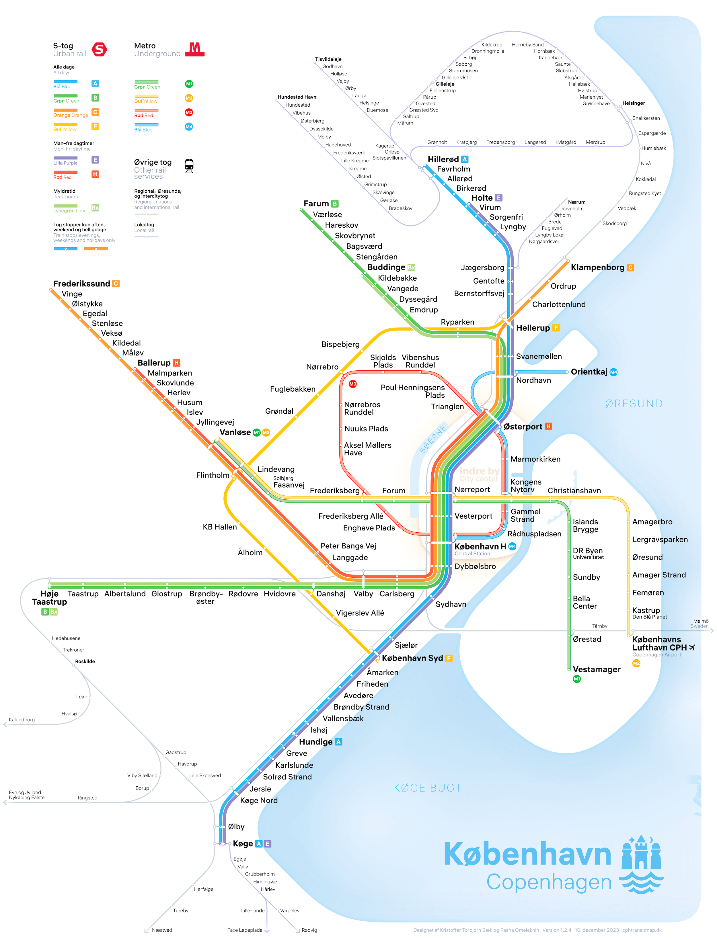
The rapid transit system of Copenhagen is undergoing a major transformation with the addition of new metro lines and light rail services. To help residents and visitors navigate the city, we have created a comprehensive and beautiful map that integrates S-train, metro, local and regional railways, as well as the upcoming light rail.
The Copenhagen train system
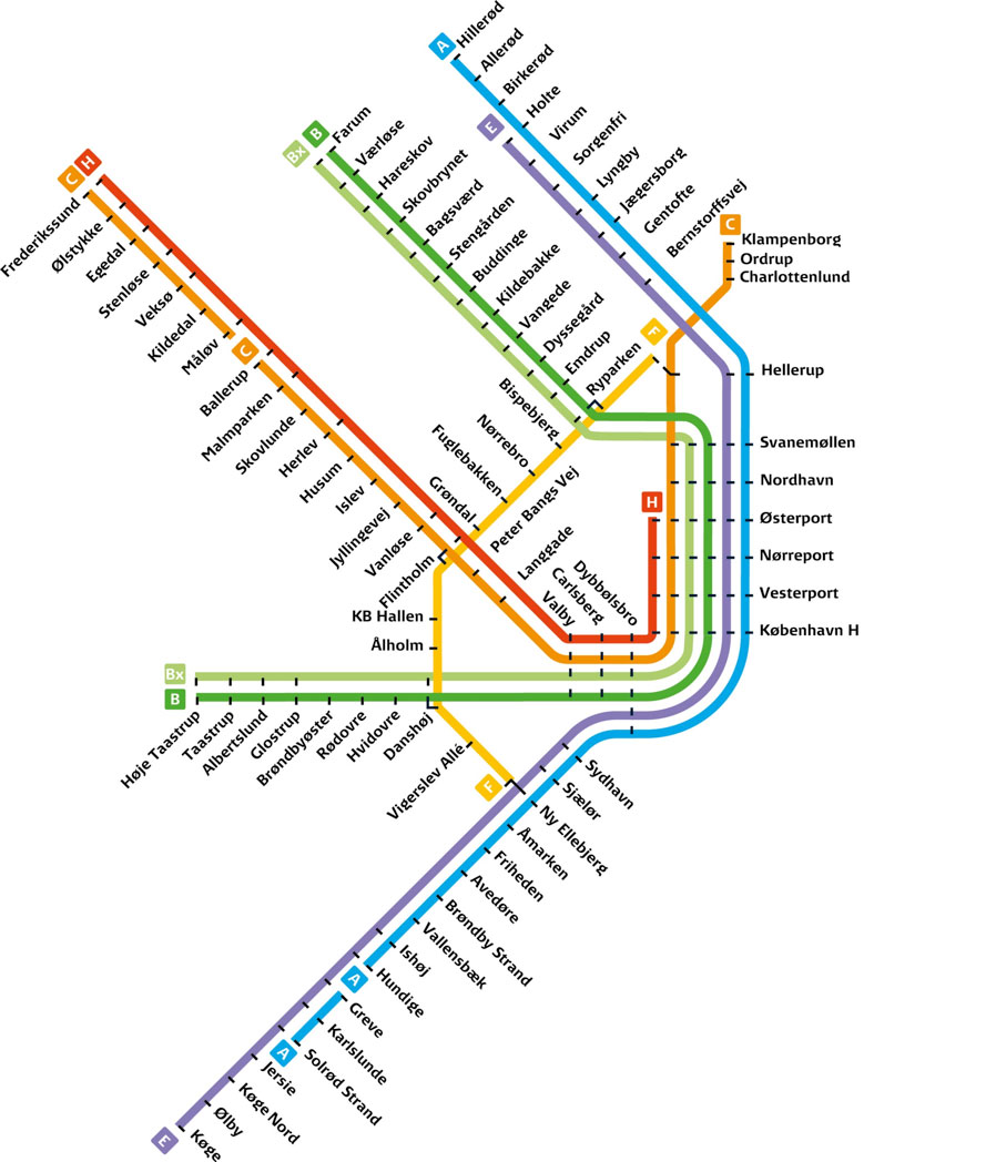
The core of Copenhagen’s public transit system was for many decades the S-trains (urban rail), allowing residents of suburban areas and nearby towns to quickly reach the city center by train. Apart from the F-line forming an outer ring, the S-train lines constitute a radial system reaching out from the city center.
In 2002, two driverless metro lines, M1 and M2, opened, crossing through the city and connecting Amager and the airport to the city center. Since 2019, two new metro lines have been added: the circle line M3, and M4, which connects developing areas in the Northern and Southern Harbor with the city center. A new light rail line will open in 2025.
We designed the first version of the map in 2019 to address the lack of integration among various transit services and the differing design styles used in existing maps. The previous official maps did not effectively combine the S-train, metro, local, and regional railways, making navigation challenging. To provide a cohesive and user-friendly experience, we decided to create a brand new unified map from scratch.
Since 2019, we have updated the map whenever necessary to ensure it remains accurate and user-friendly. With the opening of the M4 South Harbour extension in 2024 and the upcoming light rail in 2025, we’ve made several enhancements to improve clarity and ease of use. These efforts are focused on making navigation simpler and more intuitive for all users.
Official S-train map
Official metro map

Design philosophy of the new map
We wanted to create a functional and beautiful map that commuters and new riders will enjoy using, and that will pique potential visitors’ interest in Copenhagen.
We also wanted the map to show the entire rail and metro network in the Copenhagen metropolitan area, but to keep the main focus on the S-train and metro systems.
Line geometry
The shape of the lines is kept simple with a harmonious flow, so users can quickly find their station and plan their journey. Large corner radii and few directional changes make it easy follow a line’s route.

Memorable shape of the circle line
The M3 metro circle line is depicted as a recognizable diamond shape in the center of the map.
Line colors and styles
Initially, we differentiated between metro and S-train lines using distinct line styles due to similarities in their official colors (M1 with B, M2 with F, and M3 with H), which could confuse users when combined on one map. However, as of 2024, we have transitioned to using the official line colors for both networks. This change not only aligns our map more closely with the official transit scheme but also enhances clarity and usability, particularly for those familiar with Copenhagen’s official transport maps. The result is a map offering improved legibility and a more unified visual experience.
Coast, harbor and lakes
The coast around Copenhagen, together with lakes and canals, serve as important geographical landmarks in a Copenhagener’s daily life. A simplified coastline as well as an indication of the Lakes (“Søerne”) and the canal around Christianshavn are illustrated to aid geographical orientation. We also include a subtle indicator of the city center to assist visitors who are not familiar with Copenhagen.
One map for all day, every day
During weekends, evenings, and holidays, only a subset of the S-train lines runs. DSB (who operates S-trains and regional trains) uses one map for weekdays and another map for weekends, evenings, and holidays. Our new map instead provides the operating schedule in the legend, and employs a special station symbol for A- and C-line stops that are not called during daytime on weekdays.


Stations
Stops are indicated by a circular station symbol or by a unique interchange symbol for stations where users can transfer between different train systems.
All labels are horizontal which strongly aids readability. All text on the map is set in a modern clear neo-grotesque typeface.
Who made it


How can I use the map?
You can use the map freely for non-commercial purposes. For questions on licensing the map or on collaboration, please write us by @email.